There are many places on land or water in the Taunton River watershed that offer spectacular opportunities for recreation. Click here for a map of put-in sites for canoeing or kayaking.
Parks, forests and other conservation lands offer trails for hiking, fishing or swimming. They also provide the chance to experience the watershed’s rich and diverse world of forests, meadows, wetlands and streams that are homes for hundreds of species, and to observe the effects of seasonal change, weather, river and stream flow and other natural forces on the watershed’s ecosystem.
The following section lists natural areas that are owned and managed by the state agencies, municipalities or conservation organizations and are open to the public.
State-owned properties
Department of Fish and Wildlife
Burrage Pond Wildlife Management Area, Halifax and Hanson. In 2002, the Department of Fish and Wildlife purchased 1,638 acres of open space land from Northland Cranberry Company. This acquisition included Burrage Pond, cranberry bogs and upland. Trails along the former cranberry bogs provide spectacular vistas of open space and water. The area is a prime bird-watching spot that supports marsh birds, migrating passerines, wood ducks, pied-billed grebes, American kestrel; Virginia rail and many other species.
The area was once known as the Great Cedar Swamp, but the majestic Atlantic White Cedar forest was largely destroyed by diking and draining. While red maple is now the dominant forest cover, regenerating White Cedar can be spotted here and there in the former bogs.
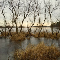
Harry C. Darling Wildlife Management Area, Hockomock Swamp
Hockomock Swamp, Easton, Raynham, West Bridgewater. This area is the largest vegetated freshwater wetland system in Massachusetts, nearly 17,000 acres in size. The swamp is a huge water reservoir. It is also the headwaters of the Town River which flows east to join the Matfield River in Bridgewater and form the Taunton. The Hockomock Swamp features a large stand of Atlantic White Cedar forest and is home to thirteen rare species listed by the Massachusetts Natural Heritage and Endangered Species Program. It is considered to be unique and irreplaceable wildlife habitat. A number of trails provide public access.
Department of Conservation and Recreation
Borderlands State Park, Easton. This beautiful park on the border of Easton and Sharon is the former estate of Blanche and Oakes Ames. It includes trails for walking and horseback riding, ponds for fishing and canoeing and the stone mansion that was the Ames family home.
Sweets Knoll State Park, Dighton. In 2011, with assistance from the Wildlands Trust, the Department of Conservation and Recreation acquired 56 acres of land off Somerset Avenue in Dighton that lies along an estuarine portion of Taunton River. Its landscape includes a knoll that overlooks the river, then a steep drop to meadows and shoreline. The Park offers picnic areas and a canoe/kayak launch.
Dighton Rock State Park, Berkeley. This 85-acre area extends from Bayview Avenue down to salt marsh bordering the Taunton River. It includes a small museum that houses “Dighton Rock,” an 11-foot high glacial erratic rock that formerly rested on the shoreline. The rock is covered with carved designs (petroglyphs) of uncertain origin.
Massasoit State Park, Taunton. Located on Middleborough Avenue in Taunton, the Park includes Lake Rico and several smaller ponds where visitors can boat or fish. There is also a campground, picnic areas and trails for hiking and mountain biking.
Watson Pond State Park, Taunton. Watson Pond State Park is a beautiful 10 acre park on Bay Street in Taunton. Open on a seasonal basis, it includes a picnic area and small pavilion, and it provides opportunities for fishing and swimming (unguarded) with a 300’ beach and a bath house. Watson Pond is fed by the Canoe River, with bordering wetlands and bogs of wild cranberry. . .
Southeastern Massachusetts Bioreserve. The Bioreserve is a mostly forested area of about 14,000 acres in Fall River and Freetown. It was established in 2010 through an Act of the state legislature, following a cooperative effort that involved the City of Fall River, the Trustees of Reservations, the Massachusetts Office of Environmental Affairs, the Department of Conservation and Recreation and the Department of Fish and Game.
The project combined the 5400 acres of the existing Fall River/Freetown State Forest with over 4,000 acres of watershed land owned by the City, about 4,000 acres of open space acquired from the Acushnet Sawmill Company and a few smaller properties. The result is a large, unfragmented block of natural habitat in the midst of three densely developed urban areas (New Bedford, Fall River and Taunton). The Bioreserve is intended to provide long-term protection for the health and biodiversity of an intact ecosystem that includes species listed as “rare” by the Massachusetts Natural Heritage Program. In addition, it offers miles of hiking trails that are open to the public, so residents of southeastern Massachusetts can experience a wilderness area close to home.
Properties owned or managed by municipalities or conservation organizations:
Lakeville: Assawompset Pond Complex. The complex is composed of five ponds: Assawompset, Pocksha, Great Quittacas, Little Quittacas and Long Pond. While the area around Long Pond is developed, it also includes hiking trails open to the public. 10,000 acres around other ponds are conservation land, including nesting sites for bald eagles.
Nuncatesset Greenway in West Bridgewater and Bridgewater. This greenway is a network of land and water trails along the Town River that connects conservation areas and urban centers.
Black Brook Conservation Area, Middleborough. Owned by The Nature Conservancy, this property offers beautiful hiking trails in the watershed of the Assawompset Ponds.
Stump Brook Wildlife Refuge, Halifax. Owned by Massachusetts Audubon Society, this property lies along Stump Brook and is contiguous to the Burrage Pond Wildlife Management Area. It includes streamside marshes and a stand of Atlantic White Cedar Swamp, with hiking trails open to the public.
Gertrude R. Boyden Wildlife Refuge, Taunton. This 50-acre property lies on the banks of the Three Mile River. It was acquired by the Taunton Conservation Commission in 1969 and includes hiking trails and views of the river and its marshes, as well as a replica of a cabin used by noted ornithologist Arthur Cleveland Bent as a site for birdwatching.
Westville Conservation Area and Idella Lewis property, Taunton. These properties also abut the Three Mile River. They are owned by the Taunton Conservation Commission and open to the public. The Idella Lewis property includes a silver maple floodplain forest, considered to be the most intact example of this declining natural community in the Commonwealth.